04/02/2015 to 04/04/2015
Back to New Mexico, one of our favorite places to visit. No, we are not getting paid by the New Mexico Chamber of Commerce to plug travel there. It just happens to have a lot of neat things to see and do.
As usual we had a long list of things we wanted to see in the Farmington area; ruins, petroglyphs, more ruins.
The weather was a little chilly and on a couple of days the winds were pretty strong, but being professionals we just layered and went on. So much fun in such a small area
- Aztec Ruins National Monument
- Angel Peak Scenic Area
- Bisti Badlands in De-Na-Zin Wilderness
- Salmon Ruins and Heritage Park
- Crow Canyon Petroglyphs - Main Panel
- Crow Canyon Petroglyphs - Big Warrior Panel
- Aztec Sandstone Arches
First thing - the Aztecs never came here. Early white settlers gave it the name Aztec. These structures were built by early Puebloan Peoples in the 11th to 13th centuries. They are similar to those in Chaco Canyon and these people probably traded with them.
Archeologist Earl H. Morris excavated the site between 1916 and 1922. In 1934 he reconstructed The Great Kiva to give people an idea of how advanced these structures were.
Today only a part of the ruins are open for visiting. Many have been recovered to preserve them.
Although the site is small it is full of great examples of Ancient Puebloan workmanship.

Aztec Ruins

Starting the walking tour

That is the reconstructed Great Kiva

Entering the Great Kiva. The color is based on pigment found at the site

Inside the Great Kiva. It is huge. The 2 vaults and central fire pit are typical of the builders.

I am in here for scale. Note the size of the pillars and surrounding balcony

Looking into the main room from the upper balcony

Moving on through the ruins you see some of the original beams and a remnant of a reed thatch


That beam at the bottom would have been part of the first floor ceiling.

A glimpse inside a room with an intact ceiling


Those are some of the ruins left exposed for visitors

George - giving scale to the height of that wall

There is a corner window in this shot. One of the only places with such a placement


Looking back at a central kiva and the Great Kiva

More walls

This is another large kiva. Those beams were part of the original ceiling, now just for display

Note the benches. All kivas had benches and a flue to pull in fresh air but keep the fire going

I am standing on the dirt looking down into one of the large kiva


This series of doors is not part of the original structure. They were made by relic hunters


This is one of the original doors that looked out onto a central area and into another room

Another original door with reed matting

That matting is over 700 years old

This is a unique double ring kiva. No idea why it has 2 rings

More walls and another kiva

Going down through more doors
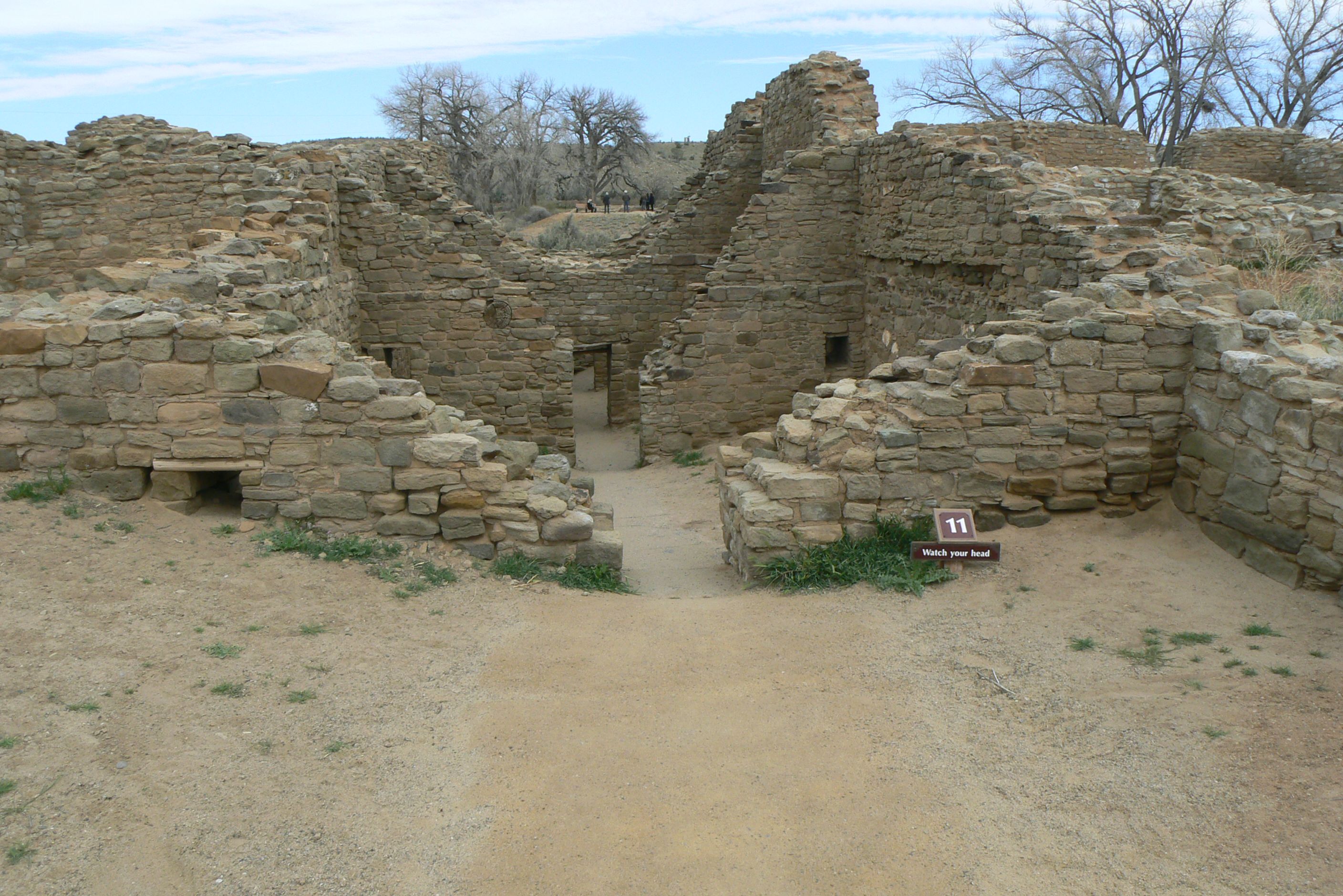

Yup, that is me scrunched down. People were a lot shorter back then

Just a nice shot of the series of doors

This is called a greywacke stone band. It is purely decorative.

The main construction is big rocks that are covered in a nice veneer of smaller stone

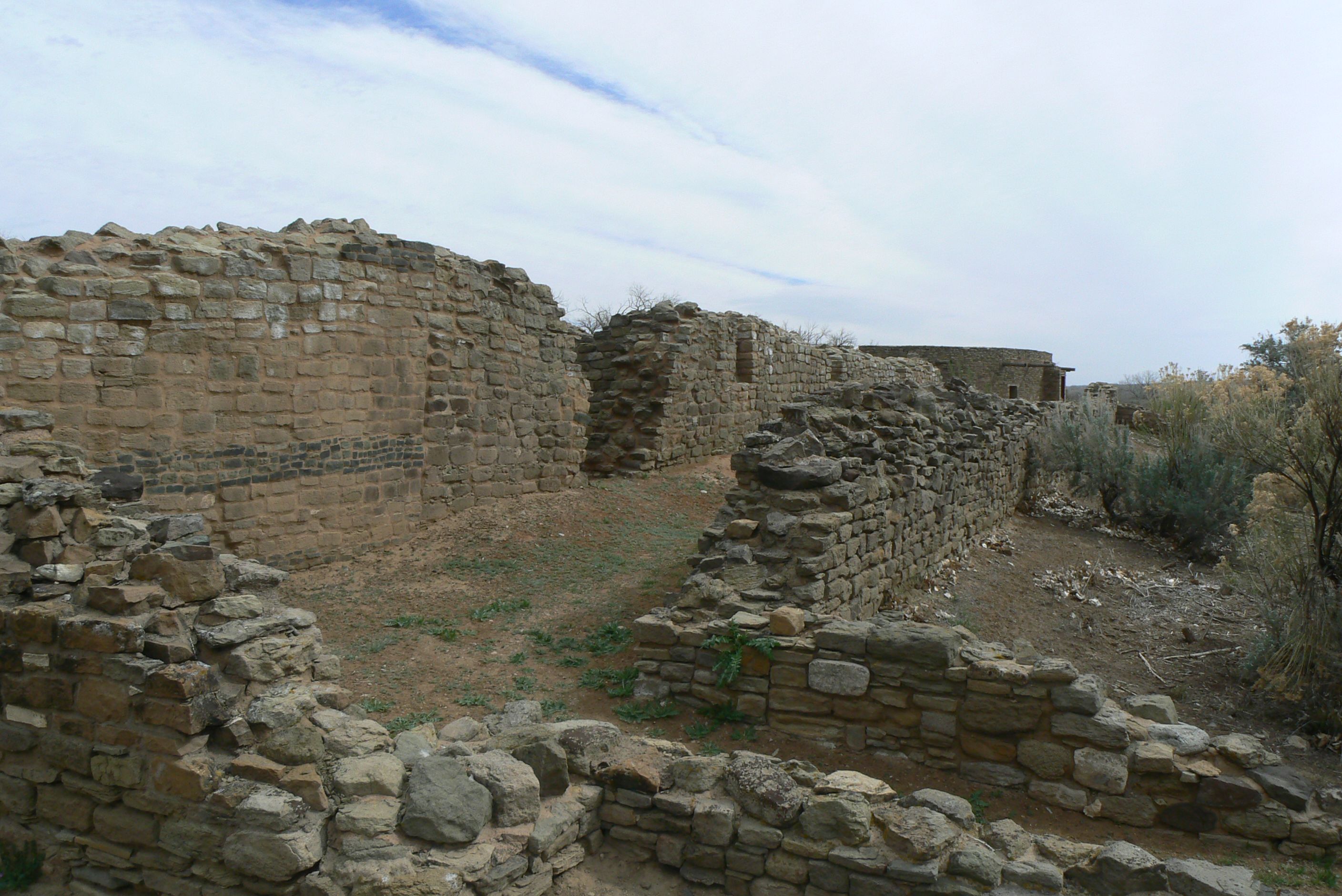
This is another section of ruins

It has a slightly isolated feel to it

Angel Peak is about 30 miles southeast of Farmington and is part of the San Juan Basin Badlands. It offers some amazing glimpses into geology that is more than 60 million years in the making.
These are sandstone and mudstone formations and the colors range from dull grey to brilliant magenta. Unfortunately our cameras do not do that justice.
It reminded us a bit of Badlands National Park in South Dakota, just not as vast and no prairie dogs or buffalo.

Angel Peak

The Badlands Overlook

Walking down the path to the overlook

One of our first glimpses


Love the different colored layers

The floor is criss-crossed with small roads


Looking across to the other side


In another section you can see trees and folds


One of the picnic areas. Great view

The color in this area was more muted


These reminded me of a fortress or huge shields stacked up by giants


And a little rock

I am calling this tuffa rock since I do not think I should use the term that comes to mind

What a view.

That big formation is Angel Peak. Note the 2 strange formations on either side

This big, solitary rock on the left like a refugee from Easter Island

And this pinnacle on the right side


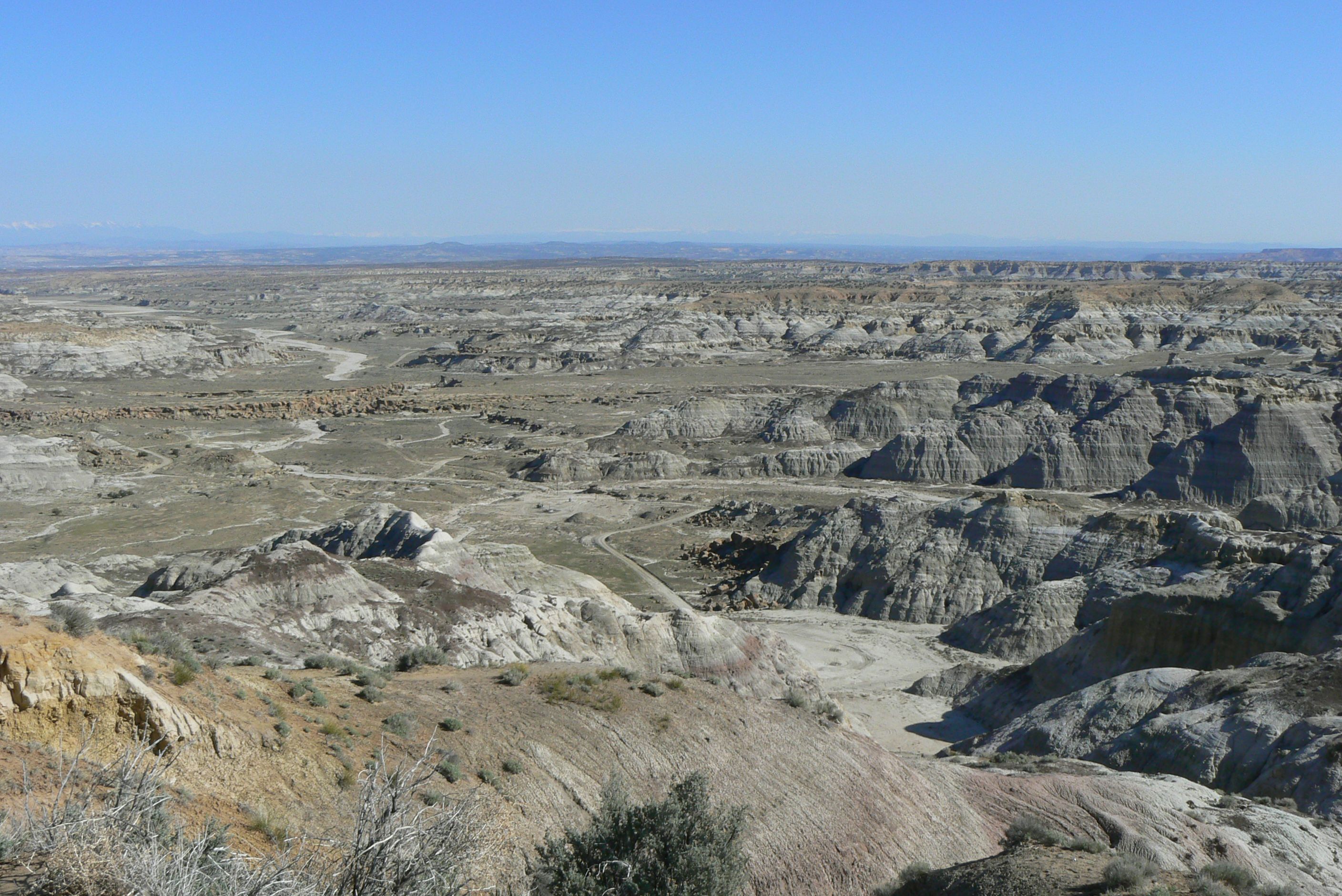
I never heard of the Bisti Badlands or De-Na-Zin Wilderness until we noticed it on our New Mexico map and our interest was peaked.
If you do not care for mud flats or odd rock formations in the middle of 4,000 square acres of high desert then move on because that is what this is.
Thankfully we love these kinds of places, and here you can go for miles without seeing anyone. We found it to be just amazing and totally enjoyed meandering around.
We took a ton of pictures because we found it all so fascinating - but then we are a bit odd.

Welcome to the wilderness

Our first odd formation. I call it necklace rock

For obvious reasons

Then climbing up and around all these black and grey formations


There is naturally occurring coal in these formations - thus the black


You can imagine water swirling around this rock

Bunny Ears

Our first glimpse of the flats

The contrasts were pretty startling

All this red. It was like a 12 mile wide pot was shattered over the area

This is one of the pieces of red rock. Looks like a pot shard does it not?

Walking on what I call a mud flat. It goes on for quite a ways

Another great red formation among the dull mud flat

Flat top

Giant bones. OK, rocks but use your imagination

See the skull with teeth

Our little bridge

We called this a lazy lizard. Better than making up things in clouds

Great rocks

A minaret

A Mamma Mountain Sheep & her 2 little ones. OK, more rocks


A toadstool

A small mountain

Teepee formation

Just great black rocks and sandstone

Tree Frog

Big tree frog


Our Skull. Arrgh maties

Our second stop was an interesting little valley

More of those pot shard


One side looked like this with great brown capped hoodoos

The other side had these amazing pointed formations


We walked to that outcrop

George loves to get up on the highest thing he can

There is a little 6 inch wide bridge that gets you here

More of those brown capped hoodoos

We thought this looked like a fish face

Just cool rocks

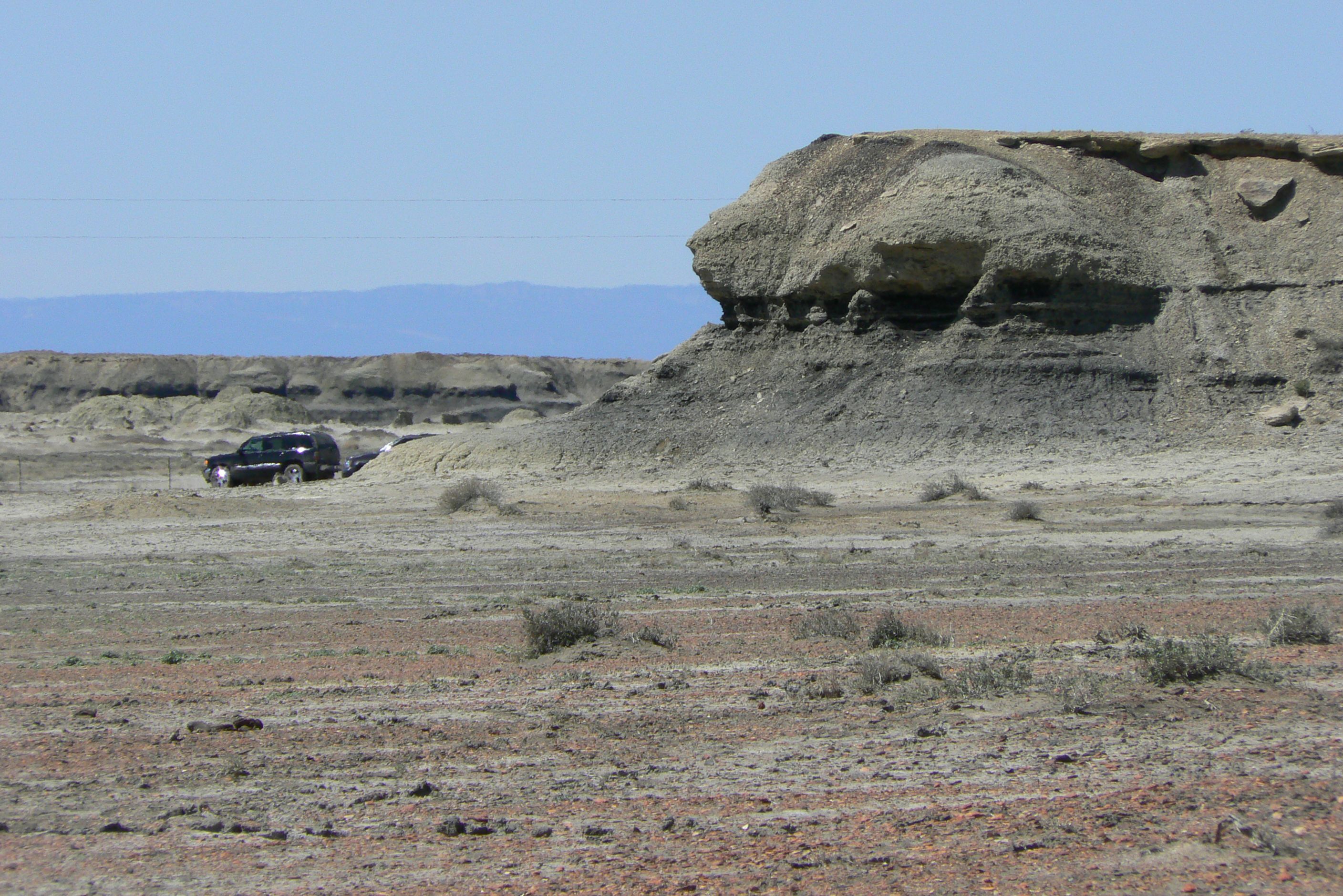
We stopped next at this cut, or small canyon

It has water running in it.
It is amazing how many Chacoan and Pueblo sites are in this area. Salmon is located a little west of Bloomfield, which is not far from Farmington.
It was constructed by migrants from Chaco Canyon around 1090. Originally there were about 300 rooms, many 3 stories high, an elevated kiva and a Great Kiva.
Like many sites in the area this one was modified by the local Middle San Juan peoples around 1120. Some of the larger rooms were divided into smaller ones and more smaller kivas were added.
And like all the others it was abandoned around 1280 and intentionally burned. Apparently stashes of corn are quite flammable due to their high sugar content. Who knew?


The park is in the middle of a residential area so it is amazing so much still exists

Besides the ruins there is and exhibit of a farmstead, hogun and ancient amphitheater

On to the ruins

One of the kiva sites. Not sure if that is what is left of the tower

You can barely make out the 2 vaults and fire pit


The rooms were used for corn storage frequently

The facade over the big stone and motor wall. They liked a nice finish


This is the only site we have seen with a round tower inside a room

When you climb up the path you realize how tall 3 stories really is.
The Crow Canyon Petroglyph Site is located in Dinetah, the traditional homeland of the Navajo people and it contains a variety of Navajo ruins and rock art from the 16th, 17th, and 18th centuries.
First let me say you really, really have to want to see these because it is 18.6 miles of dirt roads to get to there. The roads are well maintained and for us it was not an issue. Just saying.
We visited 2 of the "panels" as these are called. This one is the Main Panel and it is very extensive. You just keep walking around that cliff finding more and more pictures.
Some are so old and faded they just do not show well with our camera so I am only posting the ones that I think can be viewed. Imagine how many I would have up if all of them were clear? Need another web site just for that.

You really have to want to get here.

The area we are going to

Yes, there is a path


And some very helpful signs

The best guess at what some of the glyphs actually mean


Our first petroglyph, and an old wall. There are what seem to be 2 suns

I called this a bicycle, although I know that is not what it is

Just could not come up with any other explanation so bicycle

We have seen this trailing feather headress before in other sites

Birds and people

I have no idea. It looks like a crayfish to me, with birds


More from the birds and people pictures

More people and birds

Quite an elaborage design

The area itself is really beautiful

Every inch of rock has something carved into it.


Some funky birds


There is a sun carved in around those holes

I got George by the rocks

Holes and a sun

Just a neat hole in a rock

A man on horseback

Man on horseback

Man on horseback

2 people

Yes, it is a very tall wall

With lots of parts

I called this a village scene - with lots of stuff happening


I can understand the corn symbol the the others baffle me


Then thee is the horned guy here

No I do not think aliens came here but I do wonder


Spots with little feet and happy people


There is a totem or water sign and some riders

Back on the road - more dirt. Oh and did I mention all the natural gas in the area? Seems this part of New Mexico is the hot spot for gas and everywhere you go there are way stations, little yellow flags marking lines, and lots of warning signs.
Anyway, we drove to our next panel - Big Warrior. This is a rather small area but the entire theme seems to be warriors, thus the name.

Our original Crow Canyon sign - notice all the yellow tipped pipes. DANGER! GAS! HIGH PRESSURE!

These are everywhere

One of the one-lane bridges we crossed on our way to the petroglyph sites


OK, you have to back-track from the Main Panel to the fork in the road leading to Big Warrior

Hard to see all the dust but the truck is usually bright black


Another Pipeline Sign. They are about every 10 feet

Just scenery

More scenery. Actually this is the approach


I am in for scale again. That one big flat section in front of me holds all the carvings

Big Warrior. Not sure if that round thing is a shield

Funky bird - again. And little people

A whole band of warriors


There are just tons of these all over the area, and apparently there are some intrepid souls who actually plot them and then post their locations. The trick is successfully using your GPS - they post degrees and some GPS units use decimal.
The other trick is finding the right mile marker to pick up the dirt road. For some reason New Mexico lacks mile markers, or at least a continuous run of them. You might be looking for mile marker 10 but they end at 8. Just an added bit of interest for the search.
Even with these little obstacles we managed to visit some of the dozens listed. Again, you better like dirt roads and some arches require a little hiking and looking to locate but that is also part of the fun. Or at least we think so but then we are old and loony.

Our fist glimpse of Pillar Arch

Pillar - we climbed all over the adjacent rocks


More Pillar


Pillar from the back

Pillar Arch and a really great big stone

Next we tried to find Alien Arch but had a little trouble. We found this but it is not Alien

So we hiked around and found a fossilized worm from Tremors. Or is it a Graboid?

Ah finally found Alien Arch.

Looked like a baboon head to us

Artsy shots through the holes in Alien

Loved the 2 huge formations looking back at the baboon

This is Outcrop Arch. Took a little bit of hiking to get to it but it is easy to spot

Well easy if you get on the right dirt road.


Shot from the big rocks behind Outcrop Arch

Artsy shot through Outcrop Arch

Now we drove on to Pilares Canyon in search of Rooftop Arch. This is not it but once again the GAS!

Now this is Rooftop Arch

And the GAS pipes naturally

Rooftop is really nice, but you can miss it from the other side

Scenery around the arch

Rooftop


Further up the canyon is Peephole


Peephole has aspirations of becoming a big arch in the area one century